Date: 2019-10-01
Time: 07:00 GMT (09:00 CEST)
Place: Roznov pod Radhostem, CZ
Tracking: http://aprs.fi
This is a relaunch of the
TT7B2 tracker that was recovered in northern Croatia by Kruno 9A3SWO a couple of weeks ago and sent back to me.
| Transmissions |
| Type |
APRS |
| Callsign |
OK7DMT-2 |
| Frequency |
144.39-145.57 |
MHz |
| Period |
2 |
min |
| Transmit Power |
12.5 |
mW |
The packets are a combination of Base91 encoded position and custom telemetry data in the comment section of the packet. An online decoder and example packets can be found at this
link. The tracker transmits on local APRS frequencies. In case of GPS failure, telemetry without position is transmitted. Packets also contain backlogged data from the past 7 days.
| Flight Parameters |
| Lifting Gas |
hydrogen |
| Envelope Volume |
1.099 |
m3 |
| Envelope Mass |
224.0 |
g |
| Payload Mass |
19.1 |
g |
| Free Lift |
12.0 |
g |
| Neck Lift |
31.1 |
g |
| Initial Ascent Rate |
0.96 |
m/s |
| Expected Float Altitude |
13880 |
m |
The balloon on this flight was an obround shaped envelope 2.35m in length (flat) from a 40μm multilayer (PE/PA/EVOH/PA/PE) film. The making of the envelope is in detail described in
this blog post. A
calculator was used to obtain the flight parameters based on previously measured envelope volume, mass and payload mass. Latest atmospheric sounding data (Poprad, 20191001 0:00Z) were used to calculate the expected float altitude.
Initial ascent trajectory was modeled with
CUSF Landing Predictor, while the long term float predictions with
HYSPLIT Trajectory Model. The HYSPLIT prediction contains three altitude levels. One 500m below and another 500m above the expected float altitude.
The design of the tracker is in detail described in
this and
this blog posts. This time, the final touches consisted of securing an Energizer Ultimate Lithium AA primary battery (estimated lifetime ~60 days) to the tracker. The battery was covered in black electrical tape, and leads were soldered directly to the battery's terminals. Based on in-flight low temperature behavior of TT7B2's first flight, another layer of Glob Top epoxy was deposited on the tracker. This time, covering the whole GPS module. An initial 5 minute satellite search period was removed from the code, and the maximum duration of GPS fix reacquisition was lowered to 39 seconds.


In this case, the second thermistor/pressure sensor pair were not glued inside the envelope as the glue became the main suspect in the failure of the two previous flights. The gas inlet was heat sealed this time, and the sensors were left outside and shielded with a piece of reflective material to compare their measurements to the onboard unshielded sensors. As it was possible to hang the tracker further apart from the envelope now, the original antenna was replaced with a half wave dipole (element length: 2x 499mm). After the bad experience with TT7B1, this launch took place a couple hours later in the day, and the balloon and mainly hydrogen were left in the sun for a while to warm up.
Days 1 & 2: The balloon ascended at an average rate of 1.3m/s (maximum 3.0m/s) to an initial altitude of 13400m, about 500m below prediction. The balloon first flew over the countries of Slovakia, Poland and Ukraine. It was received by a large number of stations as these areas are well covered. The satellite images didn't show any thunderstorms nor any other high altitude clouds in the area.
After sunset the air temperature measured by the onboard thermistor fell to -63°C. As a result, the communication between the GPS module (Ublox ZOE-M8B) and the MCU began timing out. The tracker continued transmitting data packets without position for several more hours. Once it was irradiated again in the morning, the GPS module resumed operation, and the balloon was received near the Caspian Sea in Russia where it eventually entered area without APRS coverage.
The balloon held a more or less the same altitude during both days which suggests it indeed was the glue that caused the leaks on the previous two flights. Unfortunately, the balloon will most likely be stuck in a very cold air mass in the upcoming days, so it is unlikely that there will be data from the nighttime.
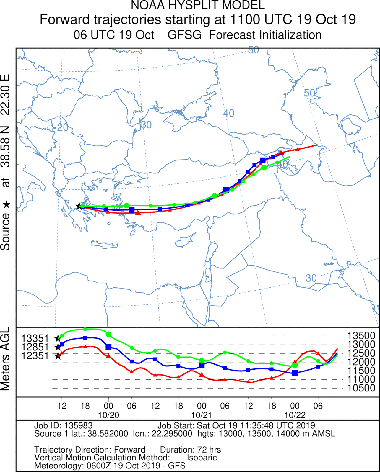
The closest that there is a chance the tracker will be received is early Friday morning around the city of Ürümqi in western China. As for high altitude clouds on the predicted path, there could be cloud tops reaching to 12600m in central Pakistan during Thursday.
Days 3-5: The balloon managed to fly over the storms in northern Pakistan, but the next morning it was too far south to be received by the Ürümqi iGates. The satellite images didn't show any clouds on the way to the east coast of China.
The first packets came through during the night from Friday to Saturday a short while after sunrise in eastern China. The balloon showed up west of Beijing and continued further east towards North Korea. For the number of iGates in the area, the reception wasn't that great and it ceased completely a bit earlier than expected. Unexpectedly, the balloon showed up again several hours later approaching Japan during local night. Great APRS coverage above Hokkaido then allowed collecting a number of backlogged data points.


The data show the balloon held its altitude at 13400-13500m during all five days. The most recent data then provide first information about its altitude during nighttime which was about 400m lower. The collection of the latest data was possible, because the temperature of the air mass in which the balloon flew rose to above -55°C during the night as can be seen in the chart. The battery voltage can be seen maintaining the same levels so far, mainly varying with the day-night cycle.
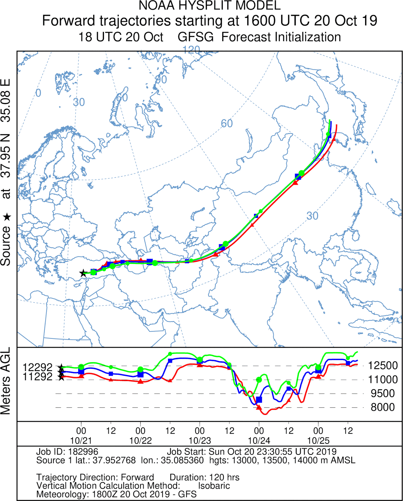
The balloon will spend a few upcoming days above the Pacific Ocean. The earliest the trajectory brings it to APRS receivers is expected on Thursday evening in California. A prediction shows cloud tops reaching 12.5km altitude above the Aleutian Islands when the balloon is scheduled to fly over during the night from Sunday to Monday.
Days 6-10: The balloon was received as the prediction suggested on its tenth day of flight in eastern California, north of Los Angeles. The satellite images from the 5 days above the Pacific Ocean show the weather on the balloon's path to be quite mild.
The balloon's trajectory during these days, reconstructed from the backlogged data, matches the Hysplit prediction. Most of the data come from daytime periods, while on the 8th of October the tracker managed to operate throughout the night as well.
The upcoming few days will be spent in North America. The balloon should get relatively quickly to the east coast of the US before leaving for Europe from Canada's Newfoundland on Sunday. As for high altitude clouds, a prediction shows cloud tops reaching up to 13.8km right on the balloon's path at the border of Missouri and Illinois on Friday.
Days 10-12: The predicted storms slightly altered the balloon's trajectory, so it showed up just south of Chicago after local sunrise instead of Missouri where I expected it.
As the APRS coverage in the US is almost omnipresent, the tracker was received throughout the whole two days as long as the Sun was above the horizon. During the night the temperatures were too low for the tracker to stay operational. As the balloon crossed the border to Canada and its sparsely populated northern Quebec, it flew out of reception again.
With more data, the previously assumed day to night variation in altitude of around 400m was most likely due to the pressure and temperature of the air mass evolving rather than the envelope stretching and contracting. Currently it seems the variation is less than 100m. The battery voltage still holds strong.
During the upcoming few days, the balloon is expected to leave Labrador and arrive in Europe. There are no adverse weather phenomena predicted over the Atlantic Ocean.
Days 13-15: The balloon arrived in Europe, specifically western coast of Spain, early in the morning on Tuesday. The first received packets were without position as it came in range prior to sunrise. The trajectory above, which matches the prediction, was reconstructed from backlogged data received during the day.
The balloon could possibly be received early in the morning at the coast of Algeria. If not, the next time it is predicted to be in range of receivers is on Friday above the eastern part of the Mediterranean Sea by which time it will have completed its first circumnavigation. The cloud tops are predicted to stay below 12km on the balloon's path with the most active regions being under the balloon at the time of writing.
Days 15-19: The balloon entered an area with very slow winds at its float altitude and didn't follow the prediction very much this time. It spent the days slowly drifting east over the Mediterranean Sea until after almost 18 days afloat and more than 36 thousand kilometers, it flew over the same meridian it had been launched from and thus completed its first circumnavigation of the Northern Hemisphere. Unfortunately, the tracker began to experience difficulties obtaining GPS fix for some unknown reason in the last few days. This results in prolonged active time and higher overall consumption shortening the tracker's potential lifespan.
In the upcoming days the balloon is predicted to continue drift east still at a relatively slow pace. It should stay within the coverage of receivers for two more days before it leaves Europe for Asia.
Days 19-20: The balloon continued its journey over Turkey, but probably due to the mountainous character of the terrain down below and decreasing number of stations was received only the first day. The satellite images show some thunderstorms over the region during the second day, but the cloud tops prediction didn't suggest anything dangerous at the balloon's altitude.


The previously mentioned issues with GPS fix acquisition unfortunately persisted and began to show up in the battery voltage levels as can be seen in the chart above. Aside from increased power consumption, it also led to a decreased accuracy and a number of obvious erroneous position reports (altitude ~30,000m kilometers away from the last report) which were removed from the data set. The issue could possibly be related to the low temperatures as the number of failed fixes seems to be the highest during mornings and evenings. The last chart shows the reported altitude to steadily decrease by more than a kilometer at one point during the latest night (as the temperature was relatively high that night, the GPS module remained responsive). Although the pressure sensor data can't be used to verify this either, I suspect the gradual decrease in altitude was also an error of the GPS module rather than an actual descent.

If the tracker remains operational, it is predicted to show up again in eastern China during the night from Thursday to Friday, or over northern Japan the following night. The cloud tops predictions for the upcoming days don't suggest any potential issues on the balloon's path.
Days 21-24: The balloon showed up in eastern China as predicted. No issues with the GPS fix acquisition were observed, but that may have been due to just a limited amount of packets that were received. I am not sure whether the APRS traffic in China is so high that only a fraction of packets make it through, or whether that is due to the existing receivers not being ideally positioned.
As the winds won't take the balloon close enough to Japan this time, the next potential reception is expected to be during the night from Sunday to Monday over Alaska. Although, the actual path may take the balloon too far from either Anchorage or Fairbanks, so that the balloon may not be heard until a day later over the west coast of Canada. There are no high clouds expected on the balloon's path during its travels over the Pacific.
Days 25-28: Unexpectedly, the balloon showed up over Kamchatka where a few packets were received by an iGate near Petropavlovsk. As I've never seen an iGate there before, it came as a surprise. On the other hand, its path over Alaska took it too far from both Anchorage and Fairbanks, so it took it a day more to be received again this time in the northern part of British Columbia.
The balloon's visit to very high latitudes followed by its return south can be seen in the first slowly decreasing then again increasing altitude data during the last several days. As the individual atmospheric layers are at lower altitudes at the poles than they are at the equator, the balloon too generally floats at slightly lower altitudes when higher in terms of latitude than when flying closer to the equator.


After the tracker sent its last packet when the Sun set in western Canada, it was supposed to travel further south and show up with sunrise in Nevada. However, it never did nor the next day. Since the area over which it was supposed to travel during those two days is very well covered by receivers, something must have happened to either the balloon or the tracker during the night. It was quite unexpected, because the battery voltage data didn't show any signs of the end of the battery's life. Should the balloon defy all odds and be received again, the above is a prediction for the upcoming 10 days. Otherwise, the image on the left provides TT7B2's complete trajectory as reconstructed from all received backlogged and live data shown in polar view.
The map shows the balloon's trajectory completed with datapoints from received backlogs. The distance covered so far is 57,355km in 27.8 days.
All the received APRS packets can be found in this text file:
TT7B2_relaunch_packets.txt
And all the decoded live and backlogged data can be found in this csv file:
TT7B2_relaunch_data.csv